


HOME>SUMMER FUN
Located within Joshinetsu National Park, Myoko is one of Japan's great outdoor areas. At 2,454 and 2,462 meters, respectively (more than 8,000 feet), Mt. Myoko and Mt. Hiuchi are the two highest mountains in Niigata prefecture (and two of the 100 Famous Mountains of Japan) and the sites for a genuine mountain-climbing experience. The Myoko area has countless hiking trails featuring forests, lakes, waterfalls and old-growth Japanese beech and birch groves. Hikers of all levels will find a trail perfect for their skill and interests.
- Mt. Myoko and Mt. Hiuchi
- Mt. Myoko is a dramatic volcanic cone set within a sweeping caldera.
Known as the Fuji of north-central Japan, it stands high
above the ski areas with its striking peaks and valleys.
Mt. Hiuchi, to the north of Mt. Myoko, is the tallest mountain
in Niigata Prefecture (it is, interestingly, a plate uplift,
not a volcano, although its neighbors are the semi-active
Mt. Yake and dormant Mt. Myoko). The area at the base of
Mt. Hiuchi is famous for its alpine flowers, which bloom
in mid- to late-July.
- Spectacular views reward those dedicated mountain climbers who reach the summits!
 1.
Mt. Myoko (2,454 meters/8,051 feet)
1.
Mt. Myoko (2,454 meters/8,051 feet)- Course: Sasagamine - Kurosawa Alpine marsh - Mt. Myoko - Tsubame Onsen. Hiking time: approx. 8 hours, 20 minutes
Starting at Sasagamine to the west of Mt. Myoko, this route crosses the open alpine marsh of Kurosawa before traveling up to the peak of Mt. Myoko, finishing to the northeast of Mt. Myoko at Tsubame Onsen. Try to leave Sasagamine in the early morning to leave adequate time to complete the route. An alternative (from July to October) is to use the Sky Cable gondola from Shin-Akakura to access the hiking path across the east face of Mt. Myoko. Return for this course can be back to Shin-Akakura, or to Tsubame Onsen.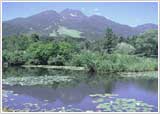 Mt. Myoko, from Imori Ike pond
- 2. Mt. Hiuchi (2,462 meters/8,077 feet)
- Sasagamine - Koya Ike (pond) - Mt. Hiuchi - Koya Ike - Kurosawa Alpine marsh - Sasagamine. Hiking time: approx. 8 hours, 55 minutes
A round trip from Sasagamine to Mt. Hiuchi, passing by the Koya Ike Hytte hut and picturesque Koya Ike (pond). The Kurosawa Alpine marsh area can be skipped on the return, but it is recommended for its unique setting and plant life. Passing through fields of flowers and marshes, this hike is highly recommended to visitors interested in Myoko's flora.
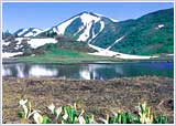 Mt. Hiuchi
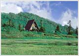 Koya Ike Hytte hut
- Sasagamine Plateau
- 3. Sasagamine Plateau
- Sasagamine Ranch - Norway Spruce forest - Shimizu ga Ike pond - Lake Otomi - Kyukamura Myoko. Total distance: 5 kilometers (3 miles). Hiking time: approx. 2 hours
-
All the charms of Sasagamine Plateau—ponds, woods, the surrounding mountains and the "ranch" (the summer pastures for area beef cattle)—fill this hiking route. This is a pastoral landscape reminiscent of Europe. You will also find superb waterfalls, local flora, and enormous Japanese beech trees on the wide selection of trails.
 Alpine flowers
 - Mt. Myoko Base Trek
- This light hike goes along the foot of Mt. Myoko.
- 4. Mt. Myoko Base Trek
- Akakura Onsen - Shin-Akakura Onsen - Imori Ike - Suginosawa - Naena Falls. Total distance 4.7 miles (7.5 km), estimated hiking time: 3.5 hours
-
This hiking trail leaves Akakura Onsen, passes by Shin-Akakura Onsen and Imori Pond (with the striking reflection of Mt. Myoko on its surface), finally arriving at Naena Falls. This hike covers quite a distance, but aside from one slope between Shin-Akakura and Ikenotaira, the trail is fairly level. This route is recommended for hikers of all experience levels.
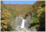 Naena Falls
A hike across the open plateau on the southwestern base of Mt. Myoko. The plateau is 1,300 meters (4,265 feet) above sea level. It is famous for the Foehn winds that often result in warm, sunny weather even when it's cloudy or rainy on the Akakura side.
)